


By Elise Harmon, news correspondent
“Back to School: Geography in the Classroom,” an exhibition curated by Stephanie Cyr, opened in the Norman B. Leventhal Map Center at the Boston Public Library (BPL) on Sept. 2.
Focusing on mapmaking and geography education in the late 18th to 20th centuries, the exhibit will be open at the Central Library location until Jan. 25, 2015. The collection of maps, artifacts, papers, textbooks, interactive media and children’s activities opened its doors last Tuesday, almost concurrently with the beginning of school for Boston grade school and university students. The “Geography in the Classroom” exhibit has appeal for fourth-graders and college seniors alike.
At a time when geography education is increasingly disregarded, Tim Cresswell, a human geographer and a Northeastern professor of history and international affairs, commented on geography in US education.
“Where I come from in the U.K., geography is well-covered,” he said. “In the US, it’s occasionally taught as part of social studies.The further you get from the US and Europe, the less people know. By the time they get to Africa, most don’t know anything at all.”
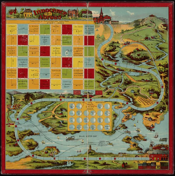
The exhibit displays entire world maps hand-drawn by young students from scratch or stitched by girls at finishing schools. The accompanying literature shows that geography was an essential part of a proper education, from primary school all the way through university level.
A Braille geography book, created in 1837 by Samuel Gridley Howe, the director of the Perkins School for the Blind, makes a commentary on how geography was deemed essential to even those who couldn’t see.
Central to the exhibit are instructional geography games and puzzles from the 1800s as well as numerous historic maps of Boston and an interactive virtual tour. A back room houses computers loaded with selected online resources and plenty of shelves full of books and atlases for those interested in delving more thoroughly into the subject.
Objects in the exhibit came from the Boston Public Library’s map collection, rare books collection and print department.
“A lot of recent exhibits have been lucky enough to have donors, but a lot of stuff in the exhibit we actually purchased for ourselves pretty recently,” Ryan Bates, a library employee, said.
A celebration of the opening of the exhibit will be held on Thursday, Sept. 11 from 5 to 7 p.m. at the Central Library. Members of the public are encouraged to attend. Refreshments will be served at 5 p.m., and the curator, Susan Schulten, will present a lecture titled “Educating a New Nation: Maps and Knowledge in 19th Century America” beginning at 6 p.m.
Since the 19th century, geography education has been marginalized in the American education system, according to the National Geographic – Roper Public Affairs 2006 Geographic Literacy Study. The study, which surveyed 510 young Americans, showed that 88 percent of participants could not find Afghanistan on a map, despite the US’s continued occupation of the country. Additionally, Northeastern does not have a geography department, which is commonplace in American universities.
Cresswell believes that since the 1950s, when the focus on geography in schools eased, college students have become increasingly unprepared for their role as global citizens.
“If you’re exposed to stories about other places and you don’t know anything about them…people in power – corporations, politicians – can tell you anything they want,” Cresswell said. “And you’ll believe them.”
Photo courtesy Boston Public Library